Invest Daily Pro
  • Economy
  • Investing
No Result
View All Result
  • Economy
  • Investing
No Result
View All Result
Invest Daily Pro
No Result
View All Result
Home Top News

Nika weakens, set to exit PAR by Tuesday afternoon

by
November 12, 2024
in Top News
0
Nika weakens, set to exit PAR by Tuesday afternoon
0
SHARES
6
VIEWS
Share on FacebookShare on Twitter
Source: PAGASA

Severe Tropical Storm Nika continues to weaken and is anticipated to exit the Philippine Area of Responsibility (PAR) by Tuesday afternoon, Philippine Atmospheric, Geophysical, and Astronomical Services Administration (PAGASA) said.  

After making landfall over Dilasag, Aurora, and sweeping across Northern Luzon on Monday, Tropical Storm Nika weakened from a typhoon to a severe tropical storm by Monday evening. 

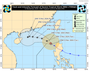
Nika now has a maximum sustained winds of 95 km/h near the center, with gusts of up to 115 km/h, according to a weather advisory released by PAGASA on Tuesday at 11:00am.  

The storm located 225 km West Northwest of Laoag City, Ilocos Norte (18.8 °N, 118.5 °E) and is moving Northwestward at a speed of 10 km/h. 

PAGASA reported that if Nika maintains its current speed, it is expected to exit the PAR by Tuesday afternoon. However, its rainbands will still directly impact parts of Luzon, bringing heavy rains and strong winds to affected areas. 

Wind Signal No. 1 remains in effect for areas including the northern part of Ilocos Norte (Sarrat, Piddig, Bangui, Vintar, Burgos, Pagudpud, Bacarra, Adams, Pasuquin, Carasi, San Nicolas, Dumalneg, Laoag City), the northern portion of Apayao (Luna, Calanasan), the northwestern portion of Cagayan (Abulug, Pamplona, Sanchez-Mira, Santa Praxedes, Claveria), and the northwestern portion of the Babuyan Islands (Islands of Calayan, Dalupiri, and Fuga). 

PAGASA warns that winds of 39-61 km/h are expected in these areas within the next 36 hours. Damage to medium to high-risk structures is possible.  

Moderate to heavy rainfall, ranging from 50 to 100 mm, is also anticipated over these areas within the next 24 hours. PAGASA cautions that this could lead to localized flooding in low-lying and urbanized zones, as well as potential landslides in highly susceptible areas. – Edg Adrian A. Eva

ShareTweetPin

Related Posts

Have a taste of the perfect day in paradise with SULÀ Spirits
Top News

Have a taste of the perfect day in paradise with SULÀ Spirits

January 8, 2025
First months of 2025 likely rainy amid La Niña conditions, says PAGASA
Top News

First months of 2025 likely rainy amid La Niña conditions, says PAGASA

January 8, 2025
December inflation rises to 2.9%
Top News

December inflation rises to 2.9%

January 7, 2025
Outstanding debt hits fresh high of P16.09T
Top News

Outstanding debt hits fresh high of P16.09T

January 7, 2025
Outstanding debt hits fresh high of P16.09T
Top News

Outstanding debt hits fresh high of P16.09T

January 7, 2025
PHL end-December dollar reserves drop to $106.8B
Top News

PHL end-December dollar reserves drop to $106.8B

January 7, 2025
Next Post
ACG drives tax reform through CREATE MORE Act

ACG drives tax reform through CREATE MORE Act

Recommended

House OKs Meralco franchise renewal on final reading

House OKs Meralco franchise renewal on final reading

November 6, 2024
Did Friday’s Reversal Mark A Major Bottom?

Did Friday’s Reversal Mark A Major Bottom?

March 9, 2025
PHL ODA funding hits $5.67 billion in 2024

PHL ODA funding hits $5.67 billion in 2024

December 23, 2024
Why Investors Are Flocking to XPEV Stock: Decoding High SCTR Scores

Why Investors Are Flocking to XPEV Stock: Decoding High SCTR Scores

March 7, 2025
Green is good: Why more developers eye green certifications for buildings

Green is good: Why more developers eye green certifications for buildings

September 8, 2024
The best books to read with kids

The best books to read with kids

October 30, 2024

    Stay updated with the latest news, exclusive offers, and special promotions. Sign up now and be the first to know! As a member, you'll receive curated content, insider tips, and invitations to exclusive events. Don't miss out on being part of something special.


    By opting in you agree to receive emails from us and our affiliates. Your information is secure and your privacy is protected.

    • About us
    • Contact us
    • Privacy Policy
    • Terms & Conditions

    Copyright © 2025 InvestDailyPro. All Rights Reserved.

    Disclaimer: InvestDailyPro.com, its managers, its employees, and assigns (collectively InvestDailyPro ) do not make any guarantee or warranty about what is advertised above. Information provided by this website is for research purposes only and should not be considered as personalized financial advice.
    The Company is not affiliated with, nor does it receive compensation from, any specific security. The Company is not registered or licensed by any governing body in any jurisdiction to give investing advice or provide investment recommendation. Any investments recommended here should be taken into consideration only after consulting with your investment advisor and after reviewing the prospectus or financial statements of the company.

    No Result
    View All Result
    • About us
    • Contact us
    • Home
    • Privacy Policy
    • Suspicious engagement
    • Terms & Conditions
    • Terms & Conditions
    • Thank you

    Copyright © 2024 investdailypro.com | All Rights Reserved